Dates ........ Saturday, September 14, 2002
Miles ........ 10.4 Miles (5.2 miles to summit, 5.2 back to base camp.)
From ........ Base Camp - Mount Katahdin - Katahdin Stream Campground - The Birches
To ............. BAXTER PEAK - SUMMIT of MOUNT KATAHDIN
Weather ... 37 degF, Cold, clear crisp early morning, summit was 50 degF, a mild breeze, clear and crisp. Later afternoon clouds moved in.Saturday, September 14, 2002
MOUNT KATAHDIN BAXTER PEAK SUMMIT and its awesome views.
We were up before 4 AM. We walked to the ranger station, separated our gear, leaving unnecessary stuff on the porch of the ranger station and carrying only food, water, extra clothes and essential gear such as maps, compass and first aid supplies up the mountain. And, my bottle of wine, of course. I loved the light pack, probably weighing in under 12 pounds. Wish it was that light always.
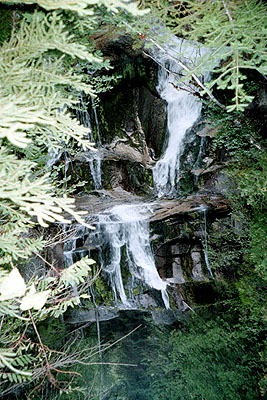
As we traipsed through the main campground we met up with Vikki and Cindy cooking breakfast in one of the picnic table shelters. They were headed up the mountain too, after their breakfast. We hugged and headed to the trail. We were signing in at the trailhead at about 5:52 AM, still dark and quite chilly. I was practically shaking with anticipation as my headlamp illuminated the dark trail. We could hear, but not see the roaring water of Katahdin Stream and its cascades. With each step it seemed to get brighter. It was just about sunrise, with a beautiful azure blue sky when we reached Katahdin Stream Falls. Mindful of the forecast for possible rain later, we moved at a steady but unhurried pace up the gentle slope.
As we climbed higher and higher the trees thinned, the rocks became larger and more prevalent, and it got brighter - but not a lot warmer. Would yesterday's ice be melted? Officially, some trails were still "closed" - but we figured that was because the day's weather forecast was not in yet (certainly it was not in when we left) and trail conditions for the day had not yet been posted. They were still operating on yesterday's trail conditions. The Appalachian Trail went up the west slope of Katahdin, so it would be delayed getting the morning rays of sun by the shadow of the gigantic mountain. We were counting on the warm rays of the sun to melt any residual ice. The ground, we noticed, so far, was not frozen. At least it was still ground, and not all rock.
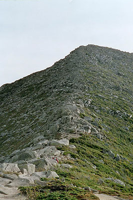
Katahdin is climbed in stages. Refer to the map enclosed in this section. Base camp is Katahdin Stream Campground, located in the foothills. Katahdin Stream Falls marks 500 feet elevation gain, and the trail gets steeper. The Cave rock formation and the treeline are close to one another and mark an elevation gain of approximately 2400 feet, about halfway up. The point of turning back and trail closures in bad weather. Also, the point at which the rocks become massive boulders and the trail gets very steep. Hunt Spur is about 300 feet above treeline and goes nearly vertical. That is the point at which I pulled myself up over boulders using the implanted iron rungs. From Hunt Spur to The Gateway is what I consider to be the most rugged section of the climb. It is a completely exposed knife-edge ridge climbing very steeply to the Tableland Plateau. It rises nearly 1000 vertical feet over a half mile of trail and is all sharp, jagged boulders which must be climbed over, around and between for a total elevation rise of about 3550 feet. Above The Gateway is the Tableland plateau, a tundra of rock, moss and grasses which rises about 750 feet over two miles, steepening somewhat near the actual summit. From Katahdin Stream Campground, it is about 4160 feet elevation increase over 5 trail miles, the roughest portion being from Katahdin Stream Falls to The Gateway. There are several other trails to the summit, but I was interested only in the Appalachian Trail.
We took a break at Hunt Spur, pondering what was the actual summit. We did not know we could not see it, even from there. We would not see the summit until we broke over The Gateway. The trail between there and The Gateway was intimidating as it fell steeply away on both sides to the basins below. A fall there would almost certainly be fatal. But we were up to it and had fantastic weather - absolutely perfect for climbing.
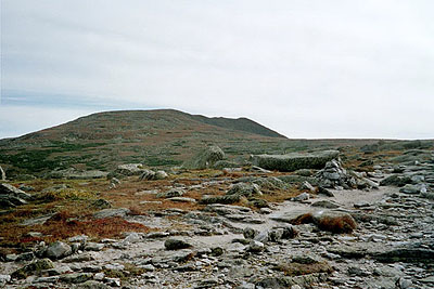
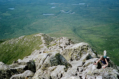
"The Gateway" and knife-edge ridge from Hunt Spur, on the way up Katahdin. Note hikers near bottom of photo. Rock by rock we worked our way up to The Gateway. There we could see the summit ahead and the whole rest of the mountain laid at our feet. We were blessed with clear blue skies, a light but pleasant breeze, and temperatures hovering near 50. The view was panoramic and awesome, but the most exciting part of it was the summit - in sight, directly ahead and just a little above us, across beautiful tundra that looked very much like a desert landscape. We passed Thoreau Spring and peered over the sharp edge of The Tableland. Then we ascended to the summit. We found little pockets of ice along the way, but nothing significant and nothing to impede our progress. Indeed, even my boots with their smooth souls were working fine. They had no problem gripping the dry rock, propelling me to the top.
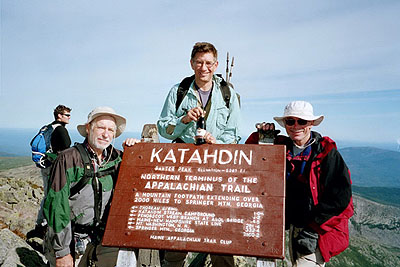
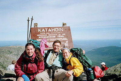
At 10:13 A.M. we reached Baxter Peak, the 5267' summit of Mount Katahdin. I cannot describe the emotion I felt at the summit. I had seen countless hundreds of smiling faces posed with the Katahdin summit sign throughout my AT travels, and in books and magazines I had read. Now, here I was. I was overjoyed at reaching my goal: completion of the 2,160 mile Appalachian Trail and at the same time I felt a great emptiness: A life-long dream was realized, I probably would not hike the AT anymore. I was euphoric with happiness and joy and tearful at the same time. I felt great pride in my accomplishment and a sense of loss simultaneously. But, clearly, the moment was one to be celebrated and long remembered.
Dozens of other climbers and hikers hugged, high-fived and let out whoops of joy. Some wept. Some seemed emotionless. Everyone enjoyed the magnificent view. The whole world seemed laid out at my feet like a giant, unending carpet. It was almost surreal, a dream. Most took turns posing at the renowned and weather-beaten summit sign, as did I. An air of celebration prevailed. After a summit snack and obligatory photos, Richard, Clinton and I headed back down, threading our way through dozens more hikers and climbers on their way to the summit. All sizes, shapes and ages from college students to old men and women were making the climb.
I took more photos, including an awesome panoramic series from the Tableland. Looking down the narrow trail descending from The Gateway was even more intimidating than looking up it. Indeed, it was just plain scary, and I'm not afraid of heights. We picked and eased our way down the big rocks and massive boulders to Hunt Spur very carefully. Going down seemed harder and more treacherous than going up. We met up with several people at different points that had gone as far as they could, or were willing to go. Most of them were waiting for someone to finish their climb and then go down with them. I met one woman that made the mistake (for her) of looking down from Hunt Spur. She became nearly paralyzed with fear and was hugging a big rock for dear life as she waited for her husband to return from the summit and help her down.
Looking down over the hump at The Gateway, the rocky knife-edge trail leads down to Hunt Spur. Note gorge in woods heading toward Elbow pond: Trail up Katahdin follows this gorge. On our way down we stopped to savor a local delicacy - wild huckleberries that grew abundantly along the trail. Oh boy, were they ever good. When we got to the bridge at Katahdin Stream, Lynn and Donna Olmstede met us. Richard and Clinton took their wives up to the Katahdin Stream Falls, and then we headed down to base camp. On our way, a snowshoe hare munched greenery along the trail. He was totally unperturbed at the growing crowd of onlookers and picture takers as he went about his business of eating. We signed back in (off the trail, climb complete) at 3:02 P.M. .
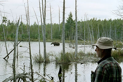
At Katahdin Stream Campground we found every parking place taken, every site occupied, but not a lot of people there. They were on the mountain. Not necessarily on the AT, perhaps on some other trail or climbing one of the many other nearby mountains. Lynn and Donna took photos of the triumphant hikers with Katahdin in the background. We retrieved our gear from the ranger station, loaded into the van and headed for Millinocket. As we left the campground we spotted a moose feeding in a nearby pond. We stopped briefly to photograph him. He too was unperturbed at our presence - probably because he was a trained moose from the Maine Tourist Bureau. Just as we were leaving, a bunch of camera toting tourists in a van labeled "Maine Wilderness and Moose Photo Tours" pulled up.
In Millinocket, Jim Yeich sat patiently in his Nissan in front of the hotel. The Olmstedes dropped me off and I was on my way home. Another great AT adventure was over. Jim and I went out to dinner and settled into our hotel room just as the heavy rain started. I can't thank Jim Yeich enough for retrieving me from this beautiful wilderness adventure and transporting me home. His many kindnesses will be long remembered.
My wine and I made it safely up Mount Katahdin and back. The wine was thoroughly enjoyed with a celebration dinner as planned. The bottle now rests in my showcase, a memento of the completion of a great journey.
THE END
|
Sun
|
Mon
|
Tue
|
Wed
|
Thur
|
Fri
|
Sat
|
| 08/21/02 | 08/23/02 | 08/24/02 | ||||
| 09/01/02 | 09/02/02 | 09/03/02 | 09/04/02 | 09/05/02 | 09/06/02 | 09/07/02 |
| 09/08/02 | 09/09/02 | 09/10/02 | 09/11/02 | 09/12/02 | 09/13/02 | 09/14/02 |
Spring/Fall hikes - 15 miles/day - Contact Al. aljohn@jmclum.com.
Last Updated 12/26/02