Dates ........ Sunday, August 18, 2002
Miles ........ 10.7 miles
From ........ Osgood Tentsite
To ............. Carter Notch Hut
Weather ... Sunny, Hot - 80's, humid.Sunday, August 18, 2002
West Branch Peabody River, Pinkham Notch NH16 & AMC camp, Ellis River, Wildcat Mt. Peak E 4041', Peak D 4063', Peak C 4270', Peak B 4270' and Wildcat Mt. Peak A 4380', Carter Notch 3388'
When I woke up I was so stiff in my legs, knees and feet I could hardly move. I could not hit the trail early with Sly the biker. I had to limber up first. I started taking my vitamin I (ibuprofen) early. The dad and son that shared their tent platform with me were nice breakfast company.
Finally, after eating my breakfast of Chex Mix, P&J sandwich, peanut butter crunch bar and a granola bar, I was ready to pack the tent and hit the trail. I got back out to the trail junction and continued the way I was going last night. Big mistake. I saw blue blazes after a half-mile or so - the wrong thing to see. I wanted the AT - white blazes. I was on a side trail leading I know not where. I had to backtrack to the trail junction, adding an extra mile of hiking to my day.
Finally on the right trail, I came to the west Branch of the Peabody River. It was so inviting I went downstream from the trail crossing, took my clothes off and bathed myself, then washed my clothes. Only two days out and they were soaked with sweat already. It felt so good. I put the wet clothes back on and resumed my hike, finally getting some decent trail into Pinkham Notch where there was a big AMC camp and full-service hiker facility. I got a turkey sub for lunch and tried to call home (busy) and mom (busy) with no luck. After a break eating the sub on the porch, I crossed the highway and resumed hiking.
The trail was nice as it meandered along the Ellis River, but it was full of tourists. Several times they and their toddlers and dogs got in my way. Soon the trail turned sharply left, away from the river and very steeply up the side of Wildcat Mountain. Signs and the AT Trail Guide warned of a very steep and dangerous climb - use extreme care. That was the end of the tourists. I climbed. It was steep. The higher I got the steeper it got. "Oh My God…The Trail goes up there??? How the H….." Stick a toe here, lift, grab a crack there, stick another toe in here…and so it went, up a nearly vertical rock cliff. Don't turn back and look down - the height is dizzying. I snap a photo of the valley and highway now so far below me. What a climb. And it kept on and on - being a steep, treacherous climb in more places than I can remember. Every muscle below my waist aches with pain. My feet feel as if the soles are on fire. Where is my strength? I'm not new at this! I make myself keep going.
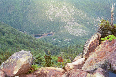
Finally I summit a peak - peak E, I think - but they are not labeled. Ah - yes - there's the ski center's gondola - it is Peak E. Then I give up some elevation and climb again, and give up more elevation, and climb again - and again - and again, until, finally, I stand atop Peak A of Wildcat Mountain. There is a "View" sign - reluctantly I take the side trail. Luckily it is short. Oh - what a view! Way down in the valley below lies Carter Hut and a couple tiny ponds. But from here, it is over 1000 feet straight down to the hut. And looking across the notch it is a nearly vertical rock wall coming up out of the notch - right where the map shows the AT to be. Oh my! What have I gotten into? Well, I have to get to that hut for water and, if I'm lucky, a place to sleep. I muster what tiny energy I have left and make myself move on.
At least its downhill - no more climbing. But I know only too well how punishing a steep, rocky downhill can be. And I'm about to be rudely reminded of that fact again. Right where the trail descends into the Notch, the contour lines on the map are so close together they form one solid dark mass. I have to keep going. I have to. I keep telling myself. One foot in front of the other. Down off this boulder. Keep going.
Uh-Oh. I come to a section of trail that is fresh, loose dirt at a horribly steep angle. A recent - real recent - landslide has wiped out the trail. About 100 feet of it has fallen to the valley below. Between me and the continuation of the trail are nothing but soft loose dirt, which may not support me, and a set of footprints. I wonder if the owner of those footprints made it across or is laying down there, hundreds of feet below with all the fresh dirt, boulders, rocks and trees. There is no alternative. Its an ugly choice but a simple one: Either try to make it across the landslide or turn back Heart in my throat, I venture out onto the soft dirt, planting one foot and both poles firmly before taking another step. Poles were a Godsend here. After an agonizing long time I cross the breach and make it to the other side, along with the other set of footprints. It feels so good to be back on terra firma again. At 7:00 P.M. I reach the hut. Again, I was late, given the distance. I usually stop hiking at 6 P.M. The terrain was far more challenging than I expected. Again.
Carter Notch Hut consisted of a central lodge with kitchen, dining area and croo quarters. Hikers stayed in the cabins, each cabin having 3 or four rooms, each room with 6 bunks. No electric except the central smoke detector system. Electric power was solar or wind generated and charged a bank of batteries. The only way in or out was by foot or air. Helicopters charged $950.00 per hour to supply the huts and could only carry 800 pounds of payload. This was a "self-service" hut ($21.00/nite), meaning you cooked your own food in the kitchen. Meals were not served as they are at a full-service hut ($65.00/nite). The main purpose of the huts is to focus hiker concentration and minimize environmental impact.
Carter Notch AMC hut nestles between Wildcat Mountain and Carter Dome. Trail ascends rocky Carter Dome, background, beyond hut. Sly and Steve, a southbounder (sobo) are there having dinner. I joined them. Sly made those tracks across the landslide. The AT and AMC would be notified and send a crew out to fix the trail - sometime. Exhausted but feeling better with a full belly, I got a bunk. Sly and Steve got the other two bunks in the same cabin. When I undressed for bed, I discovered two quarter-sized blisters on the balls of my feet. My feet were tough and seasoned, but I made a serious error today. I did not dry them thoroughly after my swim. Now I was paying for that error in judgment. I knew better, too. So I drained and bandaged the blisters and went to sleep. I was not happy. I did take a piece of advice offered by Sly. Up until now, I had always taken Vitamin I after I hurt, to try to ease pain and inflammation. Sly advised taking a hearty dose of vitamin I at bedtime, to prevent inflammation and reduce any pain that might exist or be building. Hey, I had nothing to lose so I tried it and it seemed to be far more effective, though I hated medicating myself under any conditions. I slept extremely well.
|
Sun
|
Mon
|
Tue
|
Wed
|
Thur
|
Fri
|
Sat
|
| 08/21/02 | 08/23/02 | 08/24/02 | ||||
| 09/01/02 | 09/02/02 | 09/03/02 | 09/04/02 | 09/05/02 | 09/06/02 | 09/07/02 |
| 09/08/02 | 09/09/02 | 09/10/02 | 09/11/02 | 09/12/02 | 09/13/02 | 09/14/02 |
Spring/Fall hikes - 15 miles/day - Contact Al. aljohn@jmclum.com.
Last Updated 12/26/02