Dates ........ Sunday, September 8, 2002
Miles ........ 12.7 miles, 4150' total climb
From ........ Tent camp West Branch Pleasant River
To ............. Logan Brook lean-to
Weather ... HOT - Upper 50's AM, warming to mid and upper 80's P.M. , very humidSunday, September 8, 2002
The Hermitage 695', Gulf Hagas gorge 800' Gulf Hagas Mt. 2683', West Peak 3178', Hay Mt. 3244', White Cap Mt. 3654'
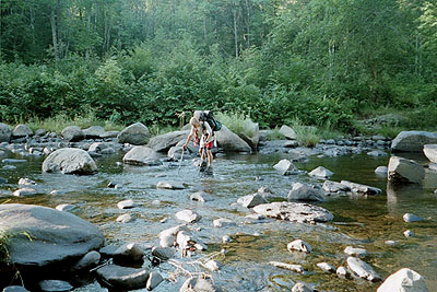
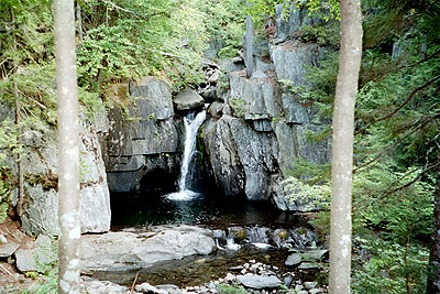
Justin and I crossed the river by rock-hopping at a point above the actual trail crossing and then working our way down to the trail crossing on the other side where we met Spyder. This was the only river crossing that had the potential to get us wet, so I was glad I sent my wading sandals back. We both crossed successfully, keeping our feet dry. These two had all the advantages of youth of their side. They danced over the rough, rocky terrain, their feet moving so fast I could barely keep up with them. We passed through the Hermitage and got to the Gulf Hagas cutoff trail and separated. I wanted to explore the Gulf, as many, including my friend Jim Yeich, had recommended it to me as a beautiful gorge well worth the extra time. My original plan had been to explore the Gulf and take the upper loop trail back to the AT but that changed after the first three waterfalls. The rocks and gorge were indeed impressive, majestic and beautiful. The water seemed a bit low, though, and was not as impressive as I imagined, though it was pretty in places. I decided to return to the AT directly after the first three falls and continue "making the miles", determined to get Whitecap, the last significant mountain until Katahdin, behind me.
One of the many beautiful pools and falls along Gulf Hagas Gorge and stream. I had four peaks to conquer today: Gulf Hagas, West Peak, Hay and White Cap Mountains. It was a lot of climbing with an initial 2100 foot climb up from the river to Gulf Hagas Mt. followed by the three other peaks, each with significant notches or saddles between them. When I finally reached Whitecap, it was steep jagged rocks most of the way up and a very rocky summit. If I did decent mileage today I would be on the way to making up the day I was behind. But I was in for an extra challenge besides the terrain. It was very humid and in the mid 80's. It was unusual, very uncomfortable weather for hiking in the northern Maine mountains this time of year, but pleasant for just about everyone else. But I pushed on. My right foot was bothering me - in back, above the heel. It felt like a mild strain. I tried different boot lacing but it seemed to make no difference. I have had no foot/ankle problems since my second week out.
On top of White Cap it was very windy, but still a hot and humid 72 degF. Usually. Mountaintops are windy and much cooler than the surrounding terrain. The wind did dry me off and felt good, but it felt that way only on the summit. There was supposed to be a great view of Katahdin, but its form could barely be made out in the thick haze. In fact, it was barely discernable from the horizon. Oh well. White Cap was the last hurdle of the day. Actually, White Cap was the last major hurdle with significant elevation until Mount Katahdin at the end of the AT. Now it was just downhill - very steep downhill - to Logan Brook and the shelter. .
I reached Logan Brook at 5:15 P.M. , very tired, hot, thirsty and hurting. I had a nasty fall on the way down, tumbling head over heels and going into an uncontrolled slide down the mountain. I saw that a tree was headed for the middle of my spread legs and immediately planted a foot on the tree, breaking my slide. Had that not been successful, I'd have become a soprano. My butt and pride injured, the former not seriously and the latter seriously, I dusted myself off, took a quick inventory of my gear and moved on. I laid part of the blame on my boots. The tread was worn smooth after about 600 trail miles, albeit rugged ones, and the leather uppers on my left boot were separating at a junction critical to being able to lace it tight. When I fell, it was my left foot that went out from under me and headed into space.
The two older brothers and slackpackers I had been running into were setting up camp, one in the Logan Brook shelter and the other on a nice streamside tentsite. Finally, after meeting them several times on the trail, I got to know them. They were very nice guys with a great sense of humor. Richard and Clint Olmstede hiked together whenever they got the chance. It was what kept them young. Their wives ran support for them, shuttling them to towns and trailheads as the trail and logging roads permitted. It was difficult and expensive in Maine since they had to pay to use the private logging roads.
I did not sleep well. I'm a back sleeper and my butt hurt, even when on my side. Maybe that will remind me to be more careful. Maybe. It only dropped to 65 degF overnight and my sheltermate snored erratically and loudly. I knew I should have pitched my tent next to the stream too. His brother knew something I didn't. Oh well, I'm sure my snoring has disturbed others from time to time.
|
Sun
|
Mon
|
Tue
|
Wed
|
Thur
|
Fri
|
Sat
|
| 08/21/02 | 08/23/02 | 08/24/02 | ||||
| 09/01/02 | 09/02/02 | 09/03/02 | 09/04/02 | 09/05/02 | 09/06/02 | 09/07/02 |
| 09/08/02 | 09/09/02 | 09/10/02 | 09/11/02 | 09/12/02 | 09/13/02 | 09/14/02 |
Spring/Fall hikes - 15 miles/day - Contact Al. aljohn@jmclum.com.
Last Updated 12/26/02