Dates ........ Tuesday, September 18, 2001
Miles ........ 16.4 miles, 5,250 foot climb
From ........ "Uncle Johnny's" Nolichucky Hostel, Irwin Tenn.
To ............. Cherry Gap Shelter
Weather ... 45 degF cool damp AM, clear, cool, sunny, calm day - 65 degFTuesday, September 18, 2001
Beauty Spot (4437'), Deep Gap (4100'), Unaka Mountain (5180')
Rested and refreshed from my stay at Uncle Johnny's, I started out at 7:30 AM. I followed the Nolichucky River up its gorge for a while before the AT broke away and headed uphill along a feeder stream. I passed through Nolichucky Campground and another hiker hostel. At points, it was extremely steep climbing up out of the river valley, just as it had been coming down into it. I had to rest frequently. My pack, refreshed with a new supply of food, seemed much heavier than previously. It should have; it was a lot heavier. By 10 AM I was at Curley Maple Gap shelter, 3080'. I had already climbed 1300 feet, but I had a lot more climbing ahead of me. It was 52 degF.
The four miles of trail between Curley Maple Gap Indian Grave Gap had no net change in elevation, but about 1000 feet of climbing and descending in a saw tooth fashion. Up one side of a knob, down the other. Up and down. Again and again. Along the way I ran into a group of day hikers from the gated community near Big Bald, about 12 women and one man. They were a lively, fun group that hiked the nearby trails regularly. We talked for a while, I answered their questions, then two of them decided to hike with me back to their car. It was nice having the photos from High Rock ridge, looking generally north and northeast, across the valley to the new highway construction. company and these gals (without packs) kept a decent pace. When we reached Indian Grave Gap, they gave me their leftover water and I had lunch next to the road.
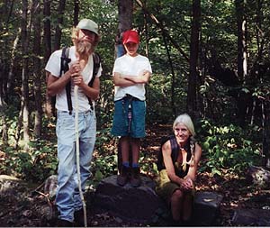
Then I had a real climb to Beauty Spot. Up and up and up some more, another 1200 feet. I wanted to stop at Beauty Spot and take a nap in the warm sunshine; to rest my aching feet and drink all my water. I settled for a 10 minute rest, a sip of water and pushed on. On my way up I met some really nice country folks. They were out for a casual day hike, enjoying the scenery of the area. They were representative of a simple hill life; dad made and sold handcrafted African drums, mom stayed home and was a mom and housewife and their young daughter was home-schooled. They made most of their own clothes and lived joyfully and simply in the beautiful river valley. It happened to be dad's 32nd birthday. They were a most refreshing family and a bright spot in my hike. I took their picture as we descended Beauty Spot.
Beauty Spot was a small bald knob on the way up to the summit of Unaka Mountain. Reputed to have spectacular views, I was disappointed because of the thick haze obscuring all but the closest mountains. I could clearly see Unaka Mt. looming above me. I really didn't feel the spirit of the climb, but I made myself do it. I wanted to get and stay ahead. As I crossed the last of Beauty Spot's open meadow, I saw a large hole in the ground with half a wasp's nest exposed. It had clear, fresh claw marks in the soft earth. A bear had his lunch here. When I crossed deep Gap in the saddle between Beauty Spot and Unaka Mt, I got stung by a bee behind the knee. Now, in addition to being tired and aching, my leg hurt. Lacking spirit, I trudged on. Up the switchbacks and the endless climb up to the summit. Near the top, a small whitetail deer seemed unconcerned at my presence and posed nicely for a photo.
Finally on top of the 5,180 foot high mountain, it didn't feel like being on a mountaintop at all. A Geological Survey marker marked the exact summit. There was absolutely no view. It felt more like being in a pine forest in a valley back home. The trees were tall, thick and dense. A thick carpet of pine needles blanketed the summit floor. If this were New Hampshire, it would be a rocky summit 1200 feet above treeline. But, I felt very much as if I'd climbed a mountain. In fact, I'd climbed almost 5,000 feet so far. I was pooped. It was a fairly steep and eroded trail downhill, not an easy glide at all. But it was far easier than climbing. I reached Low Gap, climbed its knob and descended to Cherry Gap Shelter at 6:30.
It had been a challenging day. An endurance challenge. I took off my pack, got water, ate supper and went right to bed, exhausted. I earned my rest tonight.
|
Sun
|
Mon
|
Tue
|
Wed
|
Thur
|
Fri
|
Sat
|
| 09/19/01 | 09/21/01 | 09/22/01 | ||||