Dates ........ Monday, September 10, 2001
Miles ........ 13.1 miles, climb 2809'
From ........ (Deep Gap) Groundhog Creek Shelter
To ............. Walnut Mountain Shelter (4280')
Weather ... AM: 62 degF, very cloudy & humid, dead air, no breeze. PM Hot 70's, humid, showers, higher elevations - in the cloudsMonday, September 10, 2001
Max Patch Mt (4629'), Walnut Mt. (4280')
From Groundhog Creek shelter in Deep Gap, I had about a 1600 foot climb with a 250 foot drop and re-climb over 6.5 miles to the summit of Max Patch Mt. I started about 8:10 AM. It was cloudy, very humid, about 62 degrees and the air was dead; no breeze at all. The trail was nice and smooth with gentle switchbacks on the climbs. All night I heard acorns falling to the ground - and on the noisy metal roof of the shelter. It took me a while to get used to the noise, though it was totally natural. Acorns falling from 80 feet are definitely things that go bump in the night!
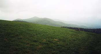
Max Patch was a disappointment, in and out of the clouds, as were the surrounding mountains. Views were very limited and hazy. I waited for it to clear, but Mother Nature did not reward my patience. I took the best pictures I could get and moved on, knowing I had lots of miles and high summits ahead of me. As I entered the woods I met two senior hikers and their dog. We chatted for a bit before I moved on to the valley. As I got water from the stream below Max Patch, it sprinkled lightly. I kept moving, not bothering with my raingear.
View southwest from Max Patch summit - in and out of the clouds.
My feet and hips are sore but my energy level seems to be high. When I reach Roaring Fork Shelter, it is thundering and there is a section hiker there setting up for the night. We talk for a while - I am amazed at the size and weight of his 60 pound pack and wonder if he will finish the journey he just started. I debate whether to push on to Walnut Mt. shelter but decide to go there after the thunder abates without rain and the hiker confirms that there is a shelter on top of Walnut Mountain. Somehow the AT guidebook and map failed to mention it. As I left the Roaring Fork shelter, elevation 3750', the ceiling dropped, clouds rolled in and it cooled off quickly. When I reached Walnut Mountain, it was really socked in, with visibility down to a hundred feet or less. The trail was a clearly defined rut in the earth and was not hard to follow. I got water, hung my gear and food, had supper and turned in, alone again. I was now two miles ahead of schedule.
|
Sun
|
Mon
|
Tue
|
Wed
|
Thur
|
Fri
|
Sat
|
| 09/19/01 | 09/21/01 | 09/22/01 | ||||