Amicalola Falls - Springer Mt. GA to
I 40 Davenport Gap, At the TN - NC border (Part 7)
Dates ........ Monday, May 6, 2002
Miles ........ 13.5 miles climb 4769', total
From ........ Fontana Dam Visitors Center NC (via Hike Inn shuttle) hike
To ............. Russell Field Shelter TN
Weather ... Sunny, breezy 60's to low 70'sMonday, May 6, 2002
Fontana Dam and Lake 1710', entering Great Smoky Mountains National Park, Shuckstack Mt and tower 4020' Doe Knob TN-NC line 4520', Devils Tater Patch 4775'
Brett "Firefly"'s knee is not up to hiking. We are both very disappointed that he has no choice but head home and see his doctor. He has several options as to how to get there, the best being able to connect with Chainsaw's wife at Fontana dam and catch a ride with them. Nancy Hoch of the Hike Inn takes us into Fontana Village to the post office where we get our mail drops. Hurriedly, I assemble and mail the package to go home. Pete "Peaks" Lane and Caribou Frank are there getting their resupply packages also. They had spent the night at the luxurious Fontana Hilton shelter.
I sat in the sunshine near the Visitors Center and assembled my P&J sandwiches. Brett hobbled up to the observation deck and took a few pictures. We chatted with the volunteers and then Brett accompanied me across the dam and to the trailhead. We both wondered what was ripping up the lawn near the park entrance sign - it was similar to what we'd seen immediately next to the AT in several places. Tracks in the soil looked like deer tracks but wider hooves. Definitely not bear (I recognize bear prints and there are none). Probably not deer, goats or sheep. What made this mess?
Reluctantly, I parted with Brett around 10 AM. If his ride with Chainsaw didn't work out, he was going to call and shuttle back to the Hike Inn and explore his other options. Nancy Hoch would shuttle him wherever he needed to go to get home. I had some serious hiking ahead of me.
From the Visitor Center at the end of the dam I could see the fire tower on top of Shuckstack Mt. That was the first destination. And it was WAY up there. On the way up, "Peaks" passed me as I was enjoying one of the four Wendy's hamburgers I had packed for the day's meals. Pete "Peaks" is one of the very few hikers I know of that does not hike with at least one hiking stick. It was a challenging, tiring, near constant climb.
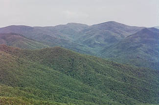
Continuing my climb, I met up with "Peaks" again, and Roger "Many Sleeps" Dunton, an AT Ridgerunner along the trail. I took a break and talked with them for a while. Roger was the quasi-official AT census taker and a bit of a legend in these parts. A spry fellow that did not show his many years, he was a real character. Definitely part of the trail and its culture. God bless him. Finally at the tower, "Peaks" was enjoying his lunch - a new product he'd discovered; chocolate peanut butter. It looked delicious and sounded wonderful. The worst of the climb over, I thought, I enjoyed the views which were awesome. Dominating the horizon was the 6643' Clingmans Dome, the highest point on the entire AT. I would be there the day after tomorrow, with any luck.
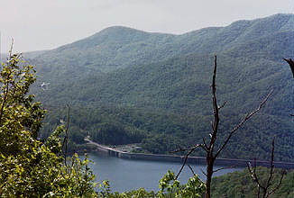
Fontana Dam and Lake from the AT .
Clingmans Dome dominates the horizon. Horses are allowed on parts of the AT in the Smokies. I can't imagine why, with all the other trails available to them. The horses really devastate the trail and make so much more work for the maintainers. Horses break down trail edges, greatly increase erosion, cause the trail to be wider and deeper, and displace erosion barriers. The first shelter listed, Birch Spring Gap, had been removed. It was now just a hitching rail and some tent pads, and the water source. I reached Doe Knob, where the AT joins and follows the NC-TN line through the Smokies. From here to I 40, the end of this segment and the Smokies for me, I will not try to differentiate between NC and TN. For practical purposes, unless significantly away from the border, it is a loosly defined border and I will be hiking with my left foot in TN and my right one in NC. The trail and the state lines are one and the same for the most part.
It was an exhausting day. Here is how the "climb" elevation is calculated. The NET climb from Fontana Lake 1710' to the highest point of the day, Devils Tater Patch 4775', is 3065 feet, which does not take into account the knobs, knolls, gaps, and mountains that a hiker must climb and descend to get there, or to his destination. The TOTAL climb for the day is over 4,769 feet calculated as follows: Fontana lake shoreline 1710' to Shuckstack 4020' = 2310', Sassafras Gp 3653' to Birch Spg Gp 3834' = 181', Birch Spg Gp 3834' to Doe Knob 4520' = 886', Mud Gp 4260' to Powell Knob 4439' = 179', Ekaneetlee Gp 3842' to Devils Tater Patch 4775' = 933', Big Abrams Gp 4080' to Russell Field Shelter 4360' (destination) = 280. 2310+181+886+179+933+280=4769. That is a lot of climbing, with a full pack, in anyone's book. It is the most I have ever done in a single day, I think. Big climbs and descents usually happen when you climb out of a river valley to a mountain. Otherwise, the AT usually does a decent job of keeping you high on a ridge and going from gap to gap (gaps are dips between mountains but are often relatively high) thus not requiring large total climbs. In other words, once you gain significant elevation, you tend to keep most of it.
I am "over the hump" as they say, once I've reached the Devil's tater Patch.
The elevation profile shows that once above the 4000 foot mark at Shuckstack Mt, and the 4500 foot mark at Doe Knob, the trail does not drop significantly below those levels again until near the end at Davenport Gap. All else being equal, climbing a 6000 foot high mountain from 4500 feet is far less strenuous than climbing a 4000 foot mountain from 1700 feet. The same applies to descents, of course. In hike planning I generally allow an hour per 1000 feet of climb in addition to figuring the hike time at 2 miles per hour, average. Really steep climbs and long climbs at the end of the day I may allow 1.5 hours per 1000 feet. I try to plan my days so the big climbs are at the beginning of the day and not the end. I can handle a big descent at the end of the day, with no problem.
Pete passed me as I got water at Birch Spring. Caribou Frank caught up with me just before the Mollies Ridge Shelter, where I got more water. It was a warm day and, with the exertion, I was going through lots of water. I was real close to an Indigo Bunting along the trail and just as Frank and I got to the Mollies Ridge shelter a large buck, his antlers just sprouting in velvet, hung around for us to admire. A French-Canadian woman was staying at that shelter. The bugs were awful - they swarmed around my head as I tried to take a short break. I moved on and left Frank and the woman chatting with each other.
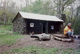
Very tired and aching, but satisfied with my accomplishments, I arrive at the Russell Field Shelter at 5:45 PM. Three other hikers and Pete Lane are there; Caribou Frank joins us later. I cannot describe how tasty and good day-old Wendy's Hamburgers are after a day spent climbing mountains. They are wonderful. I got them well done with no mayo so they'd keep OK. The trail had lots of Fraser Fir, also known as Balsam, in several places. They thrive at these altitudes and give off the freshest, cleanest pine scent there is.
|
Sun
|
Mon
|
Tue
|
Wed
|
Thur
|
Fri
|
Sat
|
| 04/24/02 | 04/26/02 | 04/27/02 | ||||
| 05/05/02 | 05/06/02 | 05/07/02 | 05/08/02 | 05/09/02 | 05/10/02 | 05/11/02 |
| 05/12/02 |