Amicalola Falls - Springer Mt. GA to
I 40 Davenport Gap, At the TN - NC border (Part 7)
Dates ........ Friday, May 3, 2002
Miles ........ 11.5 miles climb 1600', descend 4160' total
From ........ Cold Spring Shelter NC
To ............. US19 Nantahala River Outdoor Center
Weather ... 53degF, wet, windyFriday, May 3, 2002
Copper Ridge Bald NC 5200', Rocky Bald 5050', Wesser Bald 4627', Jumpup Lookout 4000', Nantahala River and Outdoor Center1740'.
It was an early start, before 8 AM, for a very wet and windy morning. We hiked a good part of the day in the clouds, in full raingear. The big challenge of the day is not the weather or the distance but the grueling downhill ahead of us. From a high of 5250 feet at Copper Ridge Bald down to the Nantahala River it was a net descent of 3510 feet and a total descent over 4160 feet.
Sure, downhill is generally preferred to uphill, but a long steep downhill is very hard on a backpackers body and can exact a toll on feet and knees. An uphill tires a hiker out but a long, rugged downhill can cause injuries that can put one out of commission. We can look forward to, or dread, the next days nearly equal uphill climb out of the river valley to the mountaontop.
We passed Larry "Chainsaw" on the ridge coming out of Cold Spring shelter. Caribou Frank had gone out ahead of us also, but we did not catch up to him. The others were behind us somewhere.
At Tellico Gap, the gap just before ascending Wesser Bald, Chainsaw caught up with us. We could see the tower looming on top of the mountain as we gained elevation. We had no idea what the view would be, but had pretty well accepted the high probability there would be only the characteristic wall of gray mist as one hikes in the clouds.
Just as we neared the summit, we rose above the clouds, out of the mist. A whitetail deer posed for us in the little side trail leading to the tower. Impatiently, wanting to seize the moment, I snapped off a shot from the trail overlook. Then we climbed the tower.
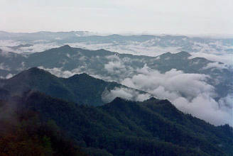
The 4627' Wesser Bald and its observation tower were a fabulous highlight of this trek. Lots of things came together to make the scenery beautiful beyond description. It had rained all night and much of the morning. Colder air and higher atmospheric pressure combined to hold the clouds and mist in the valleys while the mountains loomed skyward into the clear air. And, as luck would have it, our timing was perfect. Before the valley clouds of mist broke up and made their way up the mountains Brett and I were able to photograph them with spectacular results. We climbed the observation tower and shot a series of panoramic photos beginning north and continuing east (clockwise) until returning to the starting point. The photos north gave us a preview of what lie ahead: the Great Smoky Mountains. The photos south showed us where we had been. We were dutifully inspired.
Best of a series; a tiny portion of the spectacular view from the 4627' Wesser Bald observation tower. View is north, into the Great Smokies.
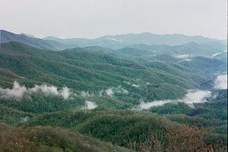
Same series: northwest from Wesser Bald tower. The view from the tower at the moment we were there was beautiful beyond imagination; even the best prose and photos could not possibly do it justice, though I certainly will try. It absolutely had to be experienced to fully appreciate it. That is why I backpack: it is the reward for my pain, sweat, and suffering, for being cold, wet, tired, too hot, for putting up with countless insects and leaky shelter roofs, hard floors and even harder miles. Experiences like this moment make it all worthwhile - and then some. Thank You, God for this moment.
It was cold atop the tower - the wind blowing briskly evaporated the sweat off our backs, chilling us. We shot our pictures and got down from the tower where we were a little sheltered from the wind. A lunch break was in order. Chainsaw came by and climbed the tower. Then we began the long descent into the Nantahala River valley. A descent that was full of little 50 to 150 foot ascents up knobs and knolls along the way.
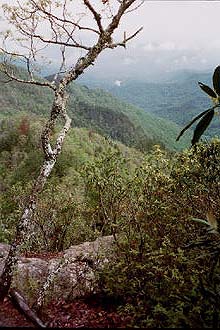
Brett was struggling. His feet were hurting. He was having problems with his toes jamming in the front of his boots. It was my hope to spend a luxurious night in the motel section of the Nantahala Outdoor Center. I knew a lot of other hikers were headed there and was concerned about getting a room. We did not have reservations and it was the weekend. Brett and I decided I should go on ahead and get a room and he could continue at a more comfortable pace. Just before the jumpup I went ahead. The jumpup came on me as a surprise. Suddenly and without warning the trail just fell away into space. I was standing on a 3 by 3 foot piece of rock at the edge of a cliff with nothing but air and distant mountains in front of me. The scenery was gorgeous. The trail took a sharp right turn and switched back and forth down a rock face then steeply down a narrow ridge. It was a challenging and interesting little piece of trail.
The "Jump Up" and view into the Nantahala River valley. I hiked through another major fire burn area, this one probably two years old, judging by the dead leaves and new growth. The woods were littered with fallen trees.
I heard traffic and smelled the pungent odor of diesel fumes before I saw the Nantahala River. About the same time I heard and saw rushing water and I was there. At the main office Caribou Frank was seated comfortably. I got a room - the last one they had. Otherwise, we'd have had to stay in the hostel. We'd have our own shower and other conveniences in a motel room. I grabbed a delicious barbeque pork sandwich and cup of clam chowder from the snack bar, then headed to the pay phone to call home. Brett came long about an hour later, obviously in pain. It was a fair hike to the room: across the river, up over the RR tracks, along the AT for a bit, along an embankment, and up a hill. Our unit was very nice, a modern style all wood contemporary.
The Nantahala Outdoor Center was the center of operations for a large outdoor outfitter and guide business. It had kayak sales, rentals and lessons, and hiker's gear as well as kayaker's gear and other outdoor gear. It operated in several whitewater rivers in the area. I was surprised to hear that it had 500 to 600 employees in peak season.
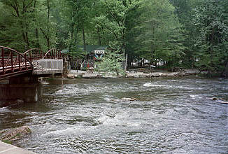
Nantahala River, part of the Outdoor Center and bridge carrying the AT across the river. We showered and cleaned up, I did laundry and dried my damp sleeping bag, then wandered back to the outfitters to get our maildrops and look at new boots for Brett. They had a nice selection of boots and Brett wisely chose mid-weight fabric and leather Gore-Tex boots that would require a minimum of break-in. They felt better than his old boots as soon as he put them on. Brett decided that he needed the new boots to continue, and a few other things as well. We'd pack up and mail back his old boots and other things he decided he did not need or want to carry up tomorrow's 3,500-foot climb.
We had an interesting dinner in their restaurant: I had an oversize burger with mushrooms and onions and fries, Brett had a fancy steak with special sauce (the days special) over a bed of mashed potatoes. Caribou Frank came in and joined us and had the same thing Brett had. We met yet another hiker from MA, Radar. We reorganized our pack, got our box of return stuff ready to go and turned in for a great night's sleep, listening to the waters of the Nantahala rush by.
|
Sun
|
Mon
|
Tue
|
Wed
|
Thur
|
Fri
|
Sat
|
| 04/24/02 | 04/26/02 | 04/27/02 | ||||
| 05/05/02 | 05/06/02 | 05/07/02 | 05/08/02 | 05/09/02 | 05/10/02 | 05/11/02 |
| 05/12/02 |